Fractional Vegetation Cover as an Alternative for Leaf Area Index


Fractional Vegetation Cover (FVC) is an important indicator of greenness and has a strong correlation with green biomass. Simultaneously, it is the key trait of interest for characterizing crop growth status in crop breeding and precision management. Why have we added this new module to Petiole Pro and how to work with it? Please, find the answers below. TEST
What is Fractional Vegetation Cover and why is it useful?
One of the earliest research papers, which features fractional vegetation cover, is “Remote estimation of soil moisture availability and fractional vegetation cover for agricultural fields“. It was published in 1990. This parameter represents the fraction of the land surface covered by green foliage in the two-dimensional plane. FVC of crops is closely related to the growth status of the crop, which can further estimate the yield of food.
Starting from that time, more and more scientists use Fractional Vegetation Cover as a parameter for evaluating crop-growth status.
How to measure Fractional Vegetation Cover for crops?
Fractional Vegetation Cover is relatively linked to Normalized Difference Vegetation Index (NDVI) and Leaf Area Index (LAI).
The basic methods to measure Fractional Vegetation Cover for crops are remote sensing, Unmanned Aerial Vehicles. For smaller crops the special equipment (like GreenSeeker) and a mobile application in a smartphone can help to measure the green foliage index.
5 Research Papers about Fractional Vegetation Cover You Must Know
On the relation between NDVI, fractional vegetation cover, and leaf area index
We use a simple radiative transfer model with vegetation, soil, and atmospheric components to illustrate how the normalized difference vegetation index (NDVI), leaf area index (LAI), and fractional vegetation cover are dependent. In particular, we suggest that LAI and fractional vegetation cover may not be independent quantities. At least when the former is defined without regard to the presence of bare patches between plants, and that the customary variation of LAI with NDVI can be explained as resulting from a variation in fractional vegetation cover.
The following points are made:
- Fractional vegetation cover and LAI are not entirely independent quantities, depending on how LAI is defined. Care must be taken in using LAI and FVC independently in a model because the former may partially take account of the latter;
- A scaled NDVI taken between the limits of minimum (bare soil) and maximum fractional vegetation cover is insensitive to atmospheric correction for both clear and hazy conditions, at least for viewing angles less than about 20 degrees from nadir;
- A simple relation between scaled NDVI and fractional vegetation cover, previously described in the literature, is further confirmed by the simulations;
- The sensitive dependence of LAI on NDVI when the former is below a value of about 2–4 may be viewed as being due to the variation in the bare soil component.
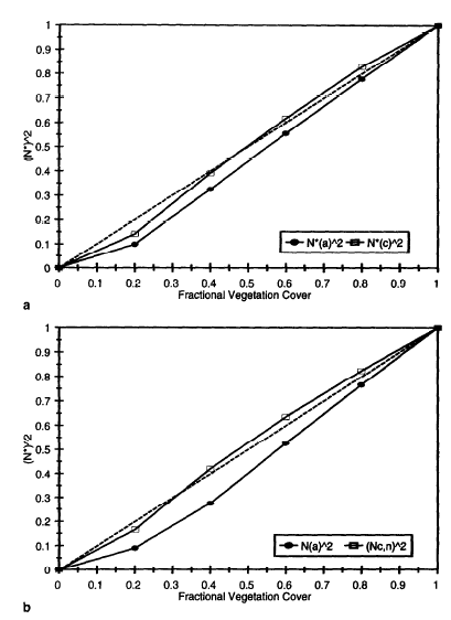
Scaled NDVI squared (N”‘) versus fractional vegetation cover based on the apparent [uncorrected, N” (a); solid circles] and corrected radiances [N”(c); open rectangles] for a threshold LAI of 3. The dashed line indicates the 1:1 correspondence; (a) 15-km visibility; (b) 5-km visibility.
Carlson, T.N.; Ripley, D.A. On the relation between NDVI, fractional vegetation cover, and leaf area index. Remote Sensing of Environment. 1997, 62, 241–252.
Method for accurate multi-growth-stage estimation of FVC using unmanned aerial vehicle remote sensing
Background
Fractional vegetation cover (FVC) is an important parameter for evaluating crop-growth status. Optical remote-sensing techniques combined with the pixel dichotomy model (PDM) are widely used to estimate cropland FVC with medium to high spatial resolution on the ground. However, PDM-based FVC estimation is limited by effects stemming from the variation of crop canopy chlorophyll content (CCC).
To overcome this difficulty, we propose herein a “fan-shaped method” (FSM) that uses a CCC spectral index (SI) and a vegetation SI to create a two-dimensional scatter map in which the three vertices represent high-CCC vegetation, low-CCC vegetation, and bare soil. The FVC at each pixel is determined based on the spatial location of the pixel in the two-dimensional scatter map, which mitigates the effects of CCC on the PDM. To evaluate the accuracy of FSM estimates of the FVC, we analyze the spectra. It was obtained from (a) the PROSAIL model and (b) a spectrometer mounted on an unmanned aerial vehicle platform. Specifically, we use both the proposed FSM and traditional remote-sensing FVC-estimation methods (both linear and nonlinear regression and PDM) to estimate soybean FVC.
Results
Field soybean CCC measurements indicate that (a) the soybean CCC increases continuously from the flowering growth stage to the later-podding growth stage, and then decreases with increasing crop growth stages, (b) the coefficient of variation of soybean CCC is very large in later growth stages (31.58–35.77%) and over all growth stages (26.14%). FVC samples with low CCC are underestimated by the PDM. Linear and nonlinear regression underestimates (overestimates) FVC samples with low (high) CCC. The proposed FSM depends less on CCC and is thus a robust method that can be used for multi-stage FVC estimation of crops with strongly varying CCC.
Conclusions
Estimates and maps of FVC based on the later growth stages and on multiple growth stages should consider the variation of crop CCC. FSM can mitigates the effect of CCC by conducting a PDM at each CCC level. The FSM is a robust method that can be used to estimate FVC based on multiple growth stages where crop CCC varies greatly.
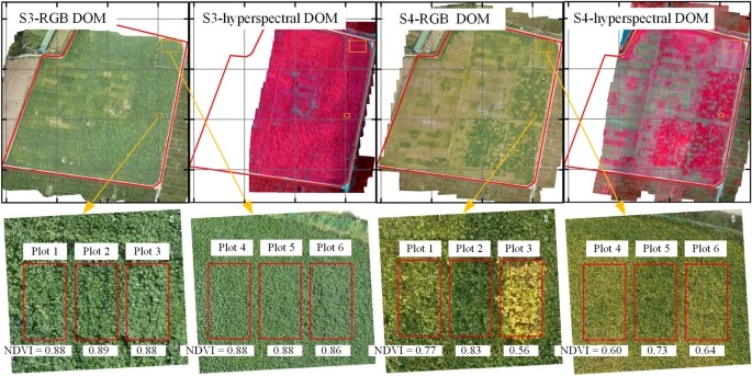
Dependence of hyperspectral images and RGB images (S3 and S4) on CCC. Note: UAV-based hyperspectral images are false-color images: R, G, B = 834, 662, and 558 nm, respectively. DOM stands for “digital orthophoto map.”
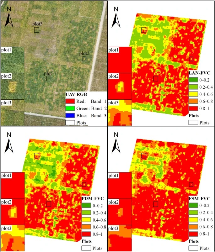
FVC mapping. Note: Plot 1: high-CCC and high FVC; Plots 2 and 3: low-CCC and high FVC
Yue, J., Guo, W., Yang, G. et al. Method for accurate multi-growth-stage estimation of fractional vegetation cover using unmanned aerial vehicle remote sensing. Plant Methods 17, 51 (2021).
Estimating Fractional Vegetation Cover of Row Crops from High Spatial Resolution Image
With high spatial resolution remote sensing images being increasingly used in precision agriculture, more details of the row structure of row crops are captured in the corresponding images.
This phenomenon is a challenge for the estimation of the fractional vegetation cover (FVC) of row crops. Previous studies have found that there is an overestimation of FVC for the early growth stage of vegetation in the current algorithms. When the row crops are a form in the early stage of vegetation, their FVC may also have overestimation.
Therefore, developing an algorithm to address this problem is necessary. This study used World-View 3 images as data sources and attempted to use the canopy reflectance model of row crops, coupling backward propagation neural networks (BPNNs) to estimate the FVC of row crops.
Results
Compared to the prevailing algorithms, i.e., empirical method, spectral mixture analysis, and continuous crop model coupling BPNNs, the results showed that the calculated accuracy of the canopy reflectance model of row crops coupling with BPNNs is the highest performing (RMSE = 0.0305).
Moreover, when the structure is obvious, we found that the FVC of row crops was about 0.5–0.6, and the relationship between estimated FVC of row crops and NDVI presented a strong exponential relationship. The results reinforced the conclusion that the canopy reflectance model of row crops coupled with BPNNs is more suitable for estimating the FVC of row crops in high-resolution images.
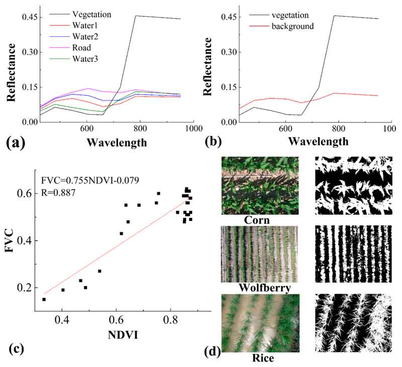
Endmembers, regression relationship, and image involved in digital photography. (a) The endmembers involved in U-SMA-2 and C-SMA-2, (b) the endmembers involved in U-SMA-5 and C-SMA-5, (c) the regression relationship between measured FVC and measured NDVI, and (d) the RGM images and binary images involved in digital cover photography.
Ma, X.; Lu, L.; Ding, J.; Zhang, F.; He, B. Estimating Fractional Vegetation Cover of Row Crops from High Spatial Resolution Image. Remote Sens. 2021, 13, 3874.
Comparison of FVC estimations using dimidiate pixel models and look-up table inversions of the PROSAIL model from Landsat 8 OLI data
Fractional vegetation cover (FVC) is an important variable for describing the quality and changes of vegetation in terrestrial ecosystems. Dimidiate pixel models and physical models are widely used to estimate FVC. Six dimidiate pixel models based on different vegetation indices (VI) and four look-up table (LUT) methods were compared to estimate FVC from Landsat 8 OLI data.
Comparisons with in situ FVC of steppe and corn showed that the model proposed by Baret et al., which is based on the normalized difference vegetation index (NDVI), predicted FVC most accurately followed by Carlson and Ripley’s method. Gutman and Ignatov’s method overestimated FVC. Modified soil adjusted vegetation index (MSAVI) and the mixture of NDVI and RVI showed potential to replace NDVI in Gutman and Ignatov’s model, whereas the difference vegetation index (DVI) performed less well.
At low vegetation cover, the LUT using reflectances to constrain the cost function performed better than LUTs using VI to constrain the cost function, whereas at high vegetation cover, the LUT based on NDVI estimated FVC most accurately. The applications of DVI and MSAVI to constrain the cost function also obtained improvement at high vegetation cover. Overall, the accuracies of LUT methods were a little lower than those of dimidiate pixel models.
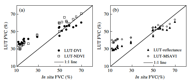
Comparison between the in situ FVC measurements and the estimated FVC using different LUTs over Hulunber site. (a) FVC estimated from LUT based on NDVI and DVI, respectively. (b) FVC estimated from LUT based on reflectance and MSAVI, respectively.
Yanling Ding, Hongyan Zhang, Zhenwang Li, Xiaoping Xin, Xingming Zheng, and Kai Zhao “Comparison of fractional vegetation cover estimations using dimidiate pixel models and look-up table inversions of the PROSAIL model from Landsat 8 OLI data,” Journal of Applied Remote Sensing 10(3), 036022 (12 September 2016).
Investigation on the Capability of GreenSeeker Sensor in Predicting Nitrogen Status and Fractional Vegetation Cover of Spinach Crop
Fractional vegetation cover (FVC) and normalized difference vegetation index (NDVI) are the most important indicators of greenness and have a strong correlation with green biomass.
The objective of this study was to evaluate a hand-held GreesnSeeker (GS) active remote sensing instrument to estimate NDVI and FVC in the spinach plant. In this study, the color indices of the G-B index and Excess Green (ExG) were used as color vegetation indices to discriminate leaves from soil background.
During 28 to 44 days after emergence (DAG), the results showed good correlations between chlorophyll yield and NDVI (R = 0.61 to 0.91), and the correlation between NDVI of GS and biomass was significant. In addition, in this growth stage, the results showed a good coefficient of correlation between NDVI of GS and FVC (R = 0.67 to 0.82).
In assessing the nitrogen rate on the NDVI of GS, the results showed significant differences only at the short period of growth stage (28 to 36 DAG). The results revealed that GreenSeeker performed well for estimation both chlorophyll and biomass yield of spinach crop and it could be used as a suitable instrument for estimation of leaf area index in the middle of the plant growth period.

The Handheld Greemseeker and height of the sensor. The same height you may apply when using Petiole Pro for measuring Fractional Vegetation Cover
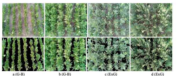
The segmentation results of the crop at a different stage of growth. a and b are early stage, c and d are the late stages of growing
Hashemi Jozani, M., H. Bagherpour, and J. Hamzei. 2022. Investigation on the Capability of GreenSeeker Sensor in Predicting Nitrogen Status and Fractional Vegetation Cover of Spinach Crop. Journal of Agricultural Machinery 12 (1): 95-106.

